


A Wake-Up Call for Melburnians Watching Australia’s East Coast Weather
We may be dry in Victoria but what is being called a fast-moving weather crisis is being experienced in New South Wales and everyone is watching, including many Melburnians as they watch and wait for what is happening in their great state just directly over the border.
According to NSW SES Deputy Commissioner Debbie Platz, this is not just another wet week:
“The system is energetic and active, and it can cause flash floods and wind gusts of 125-kmh.”
Storm damage is a possibility as NSW SES responds to coastal low Flash flood warning Flash flooding Street flooding is a threat with the storm, and the NSW SES are responding to a coastal low.
Summary

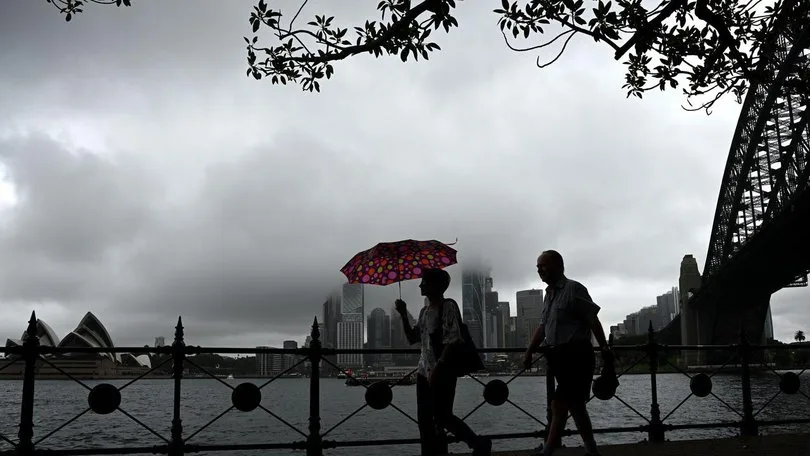
High winds and intense rain has the potential to push trees over, and create flash floods in Forster and Moruya today and tomorrow as the NSW State Emergency Service (SES) deals with the effects of a coastal low in the east.
News image
High winds and intense rain has the potential to push trees over, and create flash floods in Forster and Moruya today and tomorrow as the NSW State Emergency Service (SES) deals with the effects of a coastal low in the east.
NSW SES volunteers have been deployed in response to the effects of rain and wind across coastal communities and have been processed through 800 requests of help on Tuesday; involving over 1,000 volunteers.
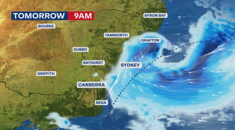
The situation is likely to deteriorate during the day. On the Hunter and Mid North Coast damaging wind gusts of up to 125km/h are predicted today (Tuesday), with the low moving southwards to Sydney, the Illawarra and South Coast.
In the South Coast, Wollongong, Blue Mountains, Sydney and the Central Coast areas, potentially destructive wind gusts may reach 110km/h during this afternoon.
Assistant Commissioner Nicole Hogan ESM said there is the potential for heavy localised falls of six-hourly rain bursts up to 120mm and this could result in flash flooding and small to medium rises in rivers.
She said flash flooding is a high risk along the east coast due to the possibility of the heavy rain cutting roads without prior warning.
Effects of such weather would be brief yet strong and we want the people to take cautions as well as messages coming in the form of emergency services.
To people that are traveling home today please be cautious not to drive through the flood and slow down. In the event that they encounter floods they should park, reverse and seek an alternative measure.”
Assistant Commissioner Hogan stated that the NSW SES was in a good stand to attend to any call towards their services by the community.

This is a weather that we have been prepared for and so we would love the community to prepare as well, she said.
Individuals ought to get to know their level of hazard by more to be knowledgeable on the local forecast and download the Hazards Near Me application, to remain up to date on the latest warnings and alerts keeping them prepared.
To seek rescue in case of an emergency by the NSW SES, please call 132 500. In case of danger to life dial Triple Zero (000).
OPERATIONAL STATISTICS:
State Operations Centre calls: 883 (5am 30 June 9am 01 July)
Statewide events: 560
Zone by zone –
- The South Eastern Zone: 99
- Metro Zone: l08
- Northern Zone: 326
- Western Zone: 2
- North Eastern Zone: 19
- North Western Zone: 2
- Southern Zone: 3
- State Units:1
- Media enquiries: 1800 067 234
What’s Happening in NSW?
A robust low pressure zone established along the NSW coastline has enhanced into a vigorous coastal low pressure gradually classified as a bomb cyclone and is hastily shifting to the south mainly.
Key risks:
- Violent wind of speed up to 125 km/h
- Severe rain showers of very short duration
- Flash floods in regional and urban regions
- Beach erosion and massive surf on the NSW beaches
The worst effects will be felt in the Sydney, Illawarra and South Coast areas from this afternoon (mid) onwards and throughout the night and into Wednesday.
Why Should Melburnians Pay Attention?
- Although Melbourne will not be affected by the storm, this weather is important due to a number of reasons:
1. Travel Disruptions
- Thinking of getting to Sydney by plane or by car? Delays are bound to take place so consider rescheduling.
- V/Line services together with freight lines into NSW can be affected.
2. There would be a possibility of shifting weather patterns.
Other low-pressure systems with a similar status have crossed into the eastern bit of Victoria in the past before and judging by how this system is currently headed towards, it is worth keeping an eye on.
3. NSW Family & Friends
The majority of the Melburnians possess family members in Sydney, Newcastle, or South Coast. It is high time to make sure that they keep their SES alerts.
SES Warnings in Place
The state Emergency Service of New South Wales has made several warnings:
This system will move south and we shall anticipate even bigger effects later this afternoon and tonight, and in the morning of tomorrow.
More than 1,300 cases of requests of aid have been already logged, and the number is increasing every hour.

What Is a Coastal Low — And Is It a Bomb Cyclone?
Coastal lows are regular storms in the east coast of Australia, but this is an aggressive one and it may even qualify as a bomb cyclone, i. e:
- Sudden decrease of atmospheric pressure (24 hPa or more in a day)
- Explosive reinforcement, fast-flowing torrents of rain and destruction winds
As opposed to the usual rain systems, this storm is not diffuse but pointy and intense: heavy rains within 1-2 hours.
Stay Safe & Stay Informed
Even from Melbourne, here’s how you can support and stay aware:
- 📱 Follow official updates: SES NSW | BOM
- 💬 Check in on loved ones: Especially those on the Central Coast, Sydney, Illawarra, or South Coast
- ✈️ Re-confirm any travel into NSW
- 📣 Share warnings: Many don’t realise how fast this system is moving
The weather event that is currently occurring in the state of NSW is severe and unpredictable, destroying coastal towns in the tail of the winds, and poses a threat of immediate flooding in metro Sydney. It may be a welcome wake-up call to Melburnians, that our collective climate can change extremely fast.
Even if you’re not in the path — be weather-aware, stay connected, and check on someone you care about.